Edmonton, Alta. (September 29, 2022) – Since GeoVerra’s inception in June 2020, the company has proudly worked with Indigenous-owned Coreman Technical Services under the Mackenzie Delta Geomatics Ltd (MDGL) partnership. This partnership has carried over from GeoVerra’s legacy companies, WSP and MMM Group, and allows GeoVerra to work in the Inuvik and Tukoyaktuk regions of the Northwest Territories (N.W.T.).
![]()
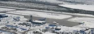
GeoVerra is excited to announce that, working as an MDGL partner, they have been awarded the contract for the Inuvik Airport runway expansion. The project will extend the runway by 3,000 feet to a total length of 9,000 feet and modernize the lighting, navigational and military aircraft landing system. This investment will allow the Royal Canadian Air Force’s (RCAF) Forward Operating Location to support a greater variety of military aircraft for RCAF and NORAD operations.
Chief Executive Officer, John Nielsen says that GeoVerra’s relationship with Coreman Technical Services and their work through MDGL is, “important to our company as we continue to work towards Indigenous Inclusion and support reconciliation efforts across the country.”
The work that started earlier this month and is expected to continue until construction is complete in 2025 includes a full suite of advanced technology solutions. The team will use UAV LiDAR surveying and terrestrial scanning, preparing blasting designs, project borrow pit layout, and construction staking for the new work areas.
“This large job is the first of many we’re hoping to capture in the N.W.T., and we’re proud to support projects that create economic opportunities and support communities and industries in this region,” says Nielsen.
About MDGL
Mackenzie Delta Geomatics provides premier geomatics solutions to pipeline, mining, industrial, oil and gas, transportation, infrastructure and energy projects in the Northwest Territories. Our core services include topographic, legal, treaty land entitlement, bathymetric and UAV surveys as well as construction layout, as-built, quantities, G.I.S., asset management, remote sensing, aerial photography, LiDAR and mapping services. We are a full service professional geomatics and land surveying firm that offers the resources and technical expertise to support local projects and long-term development opportunities.
About GeoVerra
GeoVerra is one of the country’s largest geomatics firms with offices across Western Canada and Ontario, providing land surveying, forestry, mapping, G.I.S., and advanced technology solutions to clients in diverse industries. As a team of industry experts, we are committed to exceeding expectations providing responsive, trustworthy service with a solutions-oriented approach. That’s our partnership promise.
For more information or questions regarding MDGL, please email GeoVerra’s VP, Geomatics, Damian Gillis | damian.gillis@geoverra.com.